

HYDROLOGY
GATE IES PSU’s – STUDY MATERIAL
ACE ENGINEERING ACADEMY FREE DOWNLOAD PDF

- SUBJECT : HYDROLOGY – THEORY AND WORKED OUT EXAMPLES, SELF AND CLASSROOM PRACTICE QUESTIONS
- PUBLISHERS : ACE ENGINEERING ACADEMY
- IDEAL FOR : GATE & PSUs – CIVIL ENGINEERING
- EDITION : 2014
- AUTHORS : SUBJECT EXPERTS OF ACE ENGINEERING ACADEMY, HYDERABAD
CONTENTS
- Precipitation
- Mean Precipitation Calculation
- Frequency of Point Rainfall
- Evaporation & Transpiration
- Infiltration
- Runoff
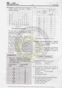
- Hydrograph
- Maximum Flood Estimation
- Flood Routing
- Well Hydraulics
- River Gauging
- Additional Questions
- Solutions for Additional Questions
BRIEF INTRO : HYDROLOGY
Hydrologic Cycle: Various components are rainfall runoff, infiltration evaporation transpiration etc. Sun is the main source of energy for this cycle. The total water resource of the earth is constant. 2. Precipitation enotes all forms of water that reach the earth from atmosphere rainfall snowfall, dew, hail etc.) Rainfall is used synonymously with precipitation. The term rainfall” is used to describe precipitations in the form of water drops of sizes larger than 0.5mm. The maximum size of a raindrop is about 6mm.
Snow: Ice crystals, combine to form flakes. Hail: Lumps of ice more than 8mm in size 3. Types of Precipitations: a) Cyclone b) Convective c) Orographic 4. Cyclone: It is a large low pressure region with circular wind motion. Isobars are closely spaced and winds are anticlockwise in the northern hemisphere. The centre of the storm is called 10 which will be relatively quiet. Outside the eye, very strong winds with speed decreasing towards outer edge
Originates in Indian Ocean, appears first in Kerala. in 9. The average annual rainfall for the entire country(India) is 119 cm and average run off is 55 cm 10. Measurement of Precipitation By rain gauges. The rain gauge is also known as Pluviometer, Ombrometer, hyetometer. No object should be nearer to the ith instrument than 30 m or twice the height of o obstruction Snowfall is measured by an equivalent depth of water. ye’, 10. Types of rain gauges: 1) Non Recording Type 2) Recording Type Ex Symon’s rain gauge(commonly used in India) Diameter of Symon’s gauge is 12.7 cm and the rim of the collector is at a height of 30cm above G.L. Symon’s gauge can also be used to measure snow fall by removing funnel and receiving bottle. 1 Recording e Gauge:It gives rainfall depth with respect to time. (i.e., intensity of rainfall, mass curve of rainfall.) Ex Tipping Bucket type, weighing bucket 12. A type, natural siphon’s type Tipping type gives intensity of rainfall. Weighing bucket type and natural siphon type give mass curve of rainfall. e Natural siphon type also called Moat type and it is the standard recording type gauge adopted by Indian standards Tipping bucket type(Telemetric gauge) is ideally suitable for mountainous and other inaccessible places 11. Raingauge network: The ratio of total area of the catchment to the total number of gauges in the catchment is defined as the ain gauge density or the network density
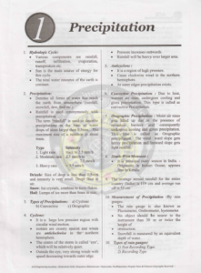
Average area served by each gauge. From the view point of accurate hydrological analysis and forecasting, therefore, the raingauge density should be as small as possible. The actual gauge density to be will be governed by many factors such as topography, climate, the state of development of the region and largely the finances available to install and maintain the network. From practical consideration of the Indian conditions, the Indian Standard Institution, has recommended the following densities
(i) One gauge per 520 km in plain areas with denser network for the areas lying in the path of low pressure systems
the period of that strong. Mass curve: A graph showing the cumulative depth of rainfall against time is known as the rainfall mass curve. A float type or weighing type recording rain gauge provides the information on rainfall mass curve. The cumulative rainfall is usually denoted by P, and expressed in mm.If any two points on the rainfall mass curve are joined by a Straight line, the slope of that line gives the average intensity of rainfall for the time period between those two points.
Evaporation: Evaporation is the process by which water from liquid or solid state passes into the vapour state and is diffused into atmosphere. Evaporation is expressed as the depth of water in mm escaped from unit area in a given time. Thus it may be expressed as mm/h, mm/day, mm/month. etc. Factors affecting evaporation: A number of factors, both meteorological and physical affect the rate of evaporation from a water body, as given below. Radiation, Temperature Wind, Atmospheric pressure, Quality of water, Size of water surface, Nature of evaporating So surface etc. Evaporation is estimated by using. i) evaporimeters ii) empirical equations, iii) Analytical methods Measurement of evaporation: Evaporation is usually measured either by altmometers or by the evaporation pans also known as the evaporimeters
Part of the precipitation is lost largely due to evaporation and infiltration. In addition to that, other minor abstractions are interception process and ii) depression storage Initial loss interception process depression storage Interception: The volume of water that is caught by vegetation and subsequently gets evaporated is called interception loss. It is only due to evaporation and does not include transpiration. The amount of precipitation intercepted by the vegetal cover depends on many factors such as density and composition of vegetation, storm characteristics and the prevailing wind at the time of storm
DOWNLOAD LINK : GATE & PSU’s – HYDROLOGY – CIVIL ENGINEERING – ACE ENGINEERING ACADEMY STUDY MATERIAL – 2014 EDITION – FREE DOWNLOAD PDF
DISCLAIMER : THIS WEBSITE IS NOT THE ORIGINAL PUBLISHER OF THIS BOOK ON NET. THIS E-BOOK HAS BEEN COLLECTED FROM OTHER SITES ON INTERNET. ALL THE RIGHTS ON THIS BOOK BELONGS TO ACE ENGINEERING ACADEMY.