

CONTENTS
- Hydrological Cycle
- Precipitation
- Measurement of Rainfall
- Evaporation
- Infiltration
- Runoff
- Stage of a River
- Stream Flow Measurement
- Unit Hydrograph
- Flood Estimation
- Reservoirs Channel Routing
- Ground Water Flow
- Groundwater Yield
- Aquifers
- Aquifuge, Aquitard and Aquiclude
- Well Hydraulics

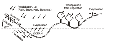
HYDROLOGICAL CYCLE
Most of the earth’s water sources, such as, rivers, lakes, oceans, and underground sources, etc. get their supplies from the rains, while rain water in itself is the evaporation from these sources. Water is lost to the atmosphere as vapour from the earth, which is then precipitated back in the form of rain, snow, hail, dew, sleet or frost, etc. This evaporation and precipitation continues and a balance is maintained between the two. This process is called hydrological cycle.
Divisions of Hydrological Cycles
IES MASTER CIVIL ENGINEERING GATE STUDY MATERIALS PDF: DOWNLOAD LINK
ACE ACADEMY CIVIL ENGINEERING GATE STUDY MATERIALS PDF: DOWNLOAD LINK
Hydrological cycle consists of two main divisions:
1. Surface Division: It consists of following:
- Transportation of water in some form
- Temporary storage
- Change from vapour to water
2. Atmospheric Division: It consists of following:
- Surface run-off, infiltration or underground water flow
- Surface ground water, soil moisture storage, and
- Change from water to vapour or evaporation due to heat
PRECIPITATION
The water which comes back to the surface of the earth in its various forms like rain, snow, hail etc. is called precipitation. A major part of the precipitation occurs in the form of rain and a minor part of the precipitation occurs in the form of snow. Other forms of precipitation such as hail, sleet, mist, etc, are all very small and generally ignored.
Types of Precipitation
1. Cyclonic Precipitation – It is of following two types:
- Frontal type: Front is a boundary joining warm moist air mass resulting in the precipitation of moist air mass.
- Non frontal type: In this cold air mass moves whereas moist air mass is stationary.
2. Convective Precipitation – It is caused due to upward movement of the air that is warmer than its surroundings. Generally it occurs in tropics, where on a hot day ground surface gets unequally heated causing the warmer air to lift up and the colder air comes to replace it. At higher altitudes it gets cooled and precipitates.
3. Orographic Precipitation – When moving warm air is obstructed by some barriers such as mountain, the moist air mass finds its way upwards where it gets cooled and precipitates. e.g: precipitation in western ghats in India.
ACE ACADEMY CIVIL ENGINEERING GATE HANDWRITTEN CLASSROOM NOTES PDF: DOWNLOAD LINK
MADE EASY CIVIL ENGINEERING GATE HANDWRITTEN CLASSROOM NOTES PDF: DOWNLOAD LINK
Measurement of Rainfall
Rainfall is measured by Raingauges. These are following two types:
1. Non-recording type: These rainguage only collect the rain and do not measure it. These are mostly used raingauge in India.
2. Recording type or Automatic: It gives a permanent rainfall record which is automatically recorded and does not need any measurement bottle to measure amount of rainfall. Amount of rainfall and its intensity gets mechanically recorded. The gauge normally consists of a rotating drum with a graph paper wrapped around. A curve showing cummulative rainfall is recorded against time. Slope of the curve gives intensity of rainfall during any given period. e.g.
- Tipping bucket type
- Weighing type
- Floating type
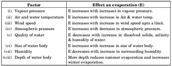
EVAPORATION – It is the process in which a liquid changes to the gaseous state at the free surface, below the boiling point through the transfer of heat energy. Evaporation is a cooling process in that the latent heat of vaporisation must be provided by water body.
Factors Affecting Rate of Evaporation
- Vapour pressures at the water surface and air above
- Air and water temperature
- Wind speed
- Atmospheric pressure
- Quality of water
- Size of the water body
- Humidity
- Depth of water in water body
Evapotranspiration (or Consumptive use of Water)
Transpiration is essentially confined to daylight hours and the rate of transpiration depends upon the growth periods of the plant. Evaporation on the other hand, continues all through the day and night although the rates are different. If sufficient moisture is always available to complete meet the needs of vegetation fully covering the area, the resulting evapotranspiration is called Potential Evapotranspiration (PET). The real evaporation occurring in a specific situation is called Actual Evapotranspiration (AET).
HYDROLOGY IES MASTER GATE STUDY MATERIAL PDF: CLICK HERE
HYDROLOGY ACE ACADEMY GATE STUDY MATERIAL PDF: CLICK HERE
INFILTRATION
When water falls on a given formation, a small part of it is first of all, absorbed by the top thin layer of soil, so as to replenish the soil moisture deficiency. Thereafter, any excess water moves downward where it is trapped in the voids and becomes ground water. This process, whereby, water enters the surface strata of the soil and moves downward, towards the water table, is called infiltration.
Hydrographs
It is graphical representation of the discharge flowing in the river, past any given section. Hence, it can easily represent sudden fluctuations in the river discharge due t o a heavy storm. It consists of flow in three Phases of Run-off
- Surface run-off
- Interflow
- Base flow.
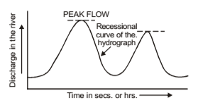
Thus two different storms in a given catchment produce hydrographs differing from each other. Similarly identical storms in two catchments produce hydrographs that are different. Hydrograph is the graphical representation of the discharge flowing in the river vs. time elapsed. It has three Characteristics Regions
- Rising limb-dimatic factors control it
- Crest segment
- Recession limb: Shape of this part of the hydrograph is independent of storm characteristics and depends entirely on the basic characteristics.
FLOOD ESTIMATION
Flood may be defined as on overflow coming from some river or from a some other body of water. River may get flooded due to an excessive rainfall or due to melting of snow or due to some other form of obstruction in the form of jams.
- Design Flood – It is the flood adopted for the design of a structure.
- Spillway Design Flood – It is the design flood used for the specific purpose of designing the spillway of a storage structure.
- Standard Projected Flood (SPF) – The flood that would result from a severe combination of meteorological and hydrological factors that are reasonably applicable to the region.
- Probable Maximum Flood (PMF) – The extreme flood that is physically possible in a region as a result of severe most combinations, including rare combinations of meteorological and hydrological factors.
HYDROLOGY ACE ACADEMY GATE CLASSROOM NOTES: CLICK HERE
HYDROLOGY MADE EASY GATE CLASSROOM NOTES: CLICK HERE
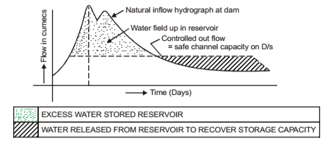
Reservoirs
When a barrier is constructed across some river in the form of a dam, water gets stored up on the up side of the barrier forming a pool of water called reservoirs.
Types of Reservoirs – Depending upon the purposes served, reservoir can be classified as follows:
- Storage or Conservation Reservoirs – These reservoirs can retain excess supplies during periods of peak flows and can release them gradually during low flow as and when the need arises.
- Flood control Reservoirs – These stores a portion of the flood flows in such a way as to minimise the flood peaks at the areas to be protected downstream. For this, entire inflow entering the reservoir is discharged till outflow reaches the safe capacity of the channel downstream.
Types of Aquifers
- Unconfined or Non-artesian Aquifers – The top most water bearing stratum having no confined impermeable overburden (i.e. aquiclude) lying over it, is called unconfined aquifer or non-artesian aquifer.
- Confined or Artesian Aquifer – When an aquifer is confined on its upper an under surface, by impervious rock formation (i.e. aquiclude), and is also broadly inclined so as to expose the aquifer for somewhere to the catchment area at higher level for the creation of sufficient hydraulic head, it is called confined aquifer or artesian aquifer.
- Perched aquifer – If within zone of saturation, an impervious deposit below a previous deposit is found to support a body of saturated material, then this is called perched aquifer. Yield from a perched aquifer is very limited.
- Aquifuge – It is that geological formation which is, neither porous nor permeable. e.g. granite rock
- Aquitard – It is that geological formation, which does not yield water to wells due to its lesser permeability. The yield from such a formation is, thus insignificant. e.g., sandy clay.
- Aquiclude – It is highly porous, containing large quantities of water, but essentially impervious. e.g. clay layer.
- Storage coefficient (A) – It is defined as the volume of water that an aquifer release or storage per unit surface area of the aquifer per unit change in the component of head normal to that surface. Storage coefficient for an artesian aquifer is equal to volume of water released from the aquifer of full height and unit area when piezometric surface declines by unity.
HYDROLOGY CIVIL ENGINEERING GATE 2020 STUDY MATERIAL FREE DOWNLOAD PDF
DOWNLOAD LINK : CLICK HERE
PASSWORD : CivilEnggForAll
OTHER USEFUL BOOKS
- CIVIL ENGINEERING TEXTBOOKS WITH DOWNLOAD LINKS
- IES MASTER CIVIL ENGINEERING GATE STUDY MATERIALS PDF
- ACE ACADEMY CIVIL ENGINEERING GATE STUDY MATERIALS PDF
- RAJASTHAN STAFF SELECTION BOARD (RSSB) JUNIOR ENGINEER DIPLOMA CIVIL ENGINEERING EXAM 2022 – HINDI & ENGLISH MEDIUM SOLVED PAPER – FREE DOWNLOAD PDF (CivilEnggForAll.com)
- ISRO TECHNICAL ASSISTANT EXAM 2022 – CIVIL ENGINEERING – HINDI & ENGLISH MEDIUM – SOLVED PAPER – FREE DOWNLOAD PDF (CivilEnggForAll.com)
- MADHYA PRADESH PUBLIC SERVICE (MPPSC) COMMISSION – ASSISTANT ENGINEER EXAM – MPPSC AE 2021 CIVIL ENGINEERING – SOLVED PAPER WITH EXPLANATIONS – PDF FREE DOWNLOAD
- BIHAR PUBLIC SERVICE COMMISSION (BPSC) ASSISTANT ENGINEER EXAM – 2022 – CIVIL ENGINEERING – SOLVED PAPER – FREE DOWNLOAD PDF (CivilEnggForAll.com)
- ODISHA PUBLIC SERVICE COMMISSION – OPSC AEE PANCHAYATI RAJ EXAM 2021 – SOLVED PAPER WITH EXPLANATION – FREE DOWNLOAD PDF