
CONTENTS
- INTRODUCTION TO SURVEYING
- FUNDAMENTALS OF MAPPING
- TYPES OF SURVEYING
- RANGING
- CHAIN AND TAPE CORRECTIONS
- PRINCIPLE OF CHAIN SURVEYING
- COMPASS SURVEYING
- PLANE TABLE SURVEYING
- METHODS OF PLANE TABLING
- LEVELLING
- TYPES OF LEVELLING OPERATION
- CORRECTIONS TO BE APPLIED
- CONTOURING
- THEODOLITE TRAVERSING
- TEMPORARY AND PERMANENT ADJUSTMENT OF DUMPY LEVEL
- TACHEOMETRIC SURVEYING
- CURVE SETTING
- ADVANCED SURVEY EQUIPMENT INTRODUCTION
- DIGITAL LEVEL
- AERIAL SURVEY
- REMOTE SENSING

INTRODUCTION
Surveying is the process of analysing and recording the characteristics of a land area span to help design a plan or map for construction. It is defined as the science of making measurements of the earth specifically the surface of the earth. This is being carried out by finding the spatial location (relative/absolute) of points on or near the surface of the earth.
Different methods and instruments are being used to facilitate the work of surveying. The primary aim of field surveying are to-
- measure the horizontal distance between points.
- measure the vertical elevation between points.
- find out the relative direction of lines by measuring horizontal angles with reference to any arbitrary direction and
- To find out absolute direction by measuring horizontal angles with reference to a fixed direction.
SURVEYING IES MASTER GATE STUDY MATERIAL : CLICK HERE
FUNDAMENTALS OF MAPPING
Following are the mapping fundamentals:-
- Scales
- Generalisation of details
- Conventional symbols
- Plotting accuracy
- Rectangular coordinate system.
OVERVIEW OF LAND SURVEYING
The fundamental objective of land surveying is to prepare a plan or map of an area. The map thus prepared serves as the primary source of information about the surface of the earth for further engineering work. The data required for making of a map gets collected through field surveying. To start field surveying it is required to know very accurately, the geographical coordinates (latitude, longitude) of at least one point, known as control point and the length as well as azimuth of a line, known as baseline. The latitude of the point and the azimuth of the line are determined through astronomical survey and longitude from time measurement. The length of the line is measured with a distance measuring instrument.
Plane Surveying
In plane surveying the curvature of the earth is not taken into consideration because it is carried out over a small area. So, the surface of the earth is considered as plane. In such surveying, a line joining any two points is considered as plane. In such surveying, a line joining any two points is considered to be straight line. The triangle form by any three points is considered as a plane triangle and the angles of the triangle are assumed to be plane angles.
Geodetic Surveying
In geodetic surveying the curvature of the earth is taken into consideration. It is extended over a large area. The line joining any two points is considered as a curved line. The triangle formed by any three points is considered to be spherical and the angle of the triangle formed of any three points is considered to be spherical and the angles of the triangle are assumed to be spherical angle. Geodetic surveying is conducted by the survey of India department, and is carried out over an area exceeding 250 km2
- Topographical surveying, is done to determine the natural features of a country.
- Cadastral surveying, is conducted in order to determine the boundaries of fields, estates, house etc.
SURVEYING ACE GATE STUDY MATERIAL : CLICK HERE
General Principle of Surveying
The general Principle of Surveying are to
- work from the whole to the part, and
- locate a new station by at least two measurements (linear or angular) from fixed reference point.
According to the first principle, the whole area is first enclosed by main station (controlling stations) and main survey line (controlling lines). The area is then divided into a number of parts by forming conditioned triangles. A nearly equilateral triangle is considered to be the best well- conditioned triangle. The main survey line is measured very accurately as a standard chain. Then the sides of the triangle are measured. The purpose of above process is to avoid accumulation of error.
Survey Stations
Main Stations
Stations taken along the boundary of an area as controlling points are known as ‘main stations.’ The lines joining the main stations are called main survey lines.
Subsidiary Stations
Stations which are on the main survey line or any other survey line are known as “subsidiary stations”. These stations are taken to run subsidiary line for dividing the area into triangle.
Tie Stations
These are also subsidiary stations taken on the main survey line. Lines joining the tie stations are known as tie lines. These lines are mainly taken to fix the directions of adjacent sides of chain survey map.
Base Line
The line on which the work of the survey is built is known as the ‘base line.’ It is the most important line of the survey. Generally, the longest of the main survey lines is considered to be the base line. This line should be taken through fairly level ground, and had to be measured very carefully and accurately.
Check Line
The line joining the apex point of a triangle to some fixed point on its base is known as the ‘check line’. It is taken to check the accuracy of the triangle. Sometimes this line helps to locate interior details.
Offset
The lateral measurement taken from an object to the chain line is known as ‘offset’. Offsets are taken to locate objects with reference to the chain line.
Cross-Staff
The cross-staff is a simple instrument for setting out right angles. There are three types of cross-staff.
Optical Square
An optical square is also used for setting out right angles. It consists of a small circular metal box of diameter 5 cm and depth 1.25 cm. It has a metal cover which slides over the box to cover the slits.
Principle
According to the principle of reflection the angle between the first incident ray and the last reflected ray is twice the angle between the mirrors. In this case, the angle between the mirrors fixed at 45°. So, the angle between the horizon sight and index sight will be 90°.
Compass Traversing
In chain surveying the area to be surveyed is divided into number of triangles. This method is suitable for fairly level ground covering small areas. But when the area is large, undulating and crowed with many detail triangulation (which is the principle of chain survey) is not possible. In such an area, the method of traversing is adopted.
Meridians
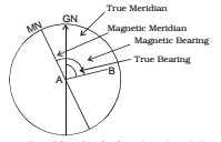
- True Meridian: The line or plane passing round the geographical north pole, geographical south pole and any point on the surface of the earth is known ‘true meridian’ of geographical meridian.
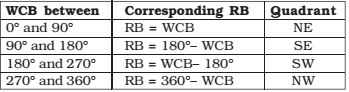
- Magnetic Meridian: When a magnetic needle is suspended freely and balanced properly, unaffected by magnetic substance, it indicate a direction. This direction is known as the ‘magnetic meridian’. The angle between the magnetic meridian and a line is known as the ‘magnetic bearing’ or simply the bearing of the line.
- Arbitrary Meridian: Sometimes for the survey of small area, a convenient direction is assumed as a meridian known as the ‘arbitrary meridian’. Sometimes the star line of a survey is taken as the arbitrary meridian. The angle between the arbitrary meridian and a line known as the ‘arbitrary bearing of the line.
- Grid Meridian: Sometimes, for preparing a map some state agencies assume several line parallel to the meridian for a particular zone. These lines are termed as ‘grid line’ and the central line the ‘grid meridian’. The bearing of a line with respect to the grid meridian is known as the ‘grid bearing’ of the line.
- Designation of Magnetic Bearing: Magnetic bearing are designated by two systems.
SURVEYING MADE EASY GATE NOTES : CLICK HERE
LEVELLING
Object of Levelling
The aim of levelling is to determine the relative heights of different objects on or below the surface of the earth and to determine the undulation of the ground surface. Below are the basic definitions involved with Levelling.
- Levelling: The art of determining the relative heights of different points on or below the surface of the earth is known as levelling. Thus, levelling deals with measurements in the vertical plane.
- Level Surface: Any surface parallel to the mean spheroidal surface of the earth is said to be a level surface. Such a surface is obviously curved. The water surface of a still lake is also considered to be a level surface.
- Level line: Any line lying on a level surface is called a level line. This line is normal to the plumb line (direction of gravity) at all points.
- Horizontal Plane: Any plane tangential to the level surface at any point is known as the horizontal plane. It is perpendicular to the plumb line which indicates the direction of gravity.
- Horizontal line: Any line lying on the horizontal plane is said to be a horizontal line. It is a straight line, tangential to the level line.
- Vertical Line: The direction indicated by a Plumb line (the direction of gravity) is known as the vertical.
- Vertical Plane: Any plane passing through the vertical line is known as the vertical plane.
- Datum surface or line: This is an imaginary level surface or level line from which the vertical distance of different points (above or below this line) are measured. In India the datum adopted form the given Trigonometrical survey (GTS) is the mean sea level (MSC) at Karachi.
- Reduced level (RL): The vertical distance of point above or below the datum line is known as the reduced level (RL) of that point. The RL of a point may be positive or negative according to as the point is above or below the datum.
- Line of collimation: It is an imaginary line passing through the intersection of the cross-hairs at the diaphragm and the optical centre of the objects glass and its continuation. It is also known as the line of sight.
- Axis of the telescope: It is an imaginary line passing through the optical centre of the object glass and the optical centre of the eye-piece.
- Axis of bubble tube: It is an imaginary line tangential to the longitudinal curve of the bubble tube at its middle point.
- Benchmarks (BM): These are fixed points or marks of known RL determined with reference to the datum line. These are very important marks. These survey as open in projects are involved in roadways, railway etc. Bench-marks may be of four type (a) GTS (b) Permanent (c) temporary and (d) arbitrary.
- Back-sight reading (BS): This is the first staff reading taken in any set up of the instrument after the levelling has been perfectly done. This reading is always taken on a point of known RL, on a bench-mark or change point.
- Foresight reading (FS): It is the last staff reading in any set up of the instrument, and indicates the shifting of the latter.
- Intermediate Sight Reading (IS): It is any other state reading between the BS and FS in the same set up of the instrument.
- Change Point (CP): This point indicates the shifting of the instrument. At this point, an FS is taken from one setting and BS from the next setting.
- Height of Instrument (HI): When the levelling instrument is properly levelled, the RL of the line of collimation is known as the height of the instrument. This is obtained by adding the BS reading to the RL or CP on which the staff reading was taken.
- Focussing: The operation of setting the eyepiece end the object glass is at a proper distance apart for clear vision of the object is known as focussing. This is done by turning the focussing screw clockwise or anticlockwise.
- Diaphragm: The diaphragm is a brass ring fitted inside the telescope, just in front of the eyepiece. It can be adjusted by four screws. The ring carries the cross-hair, which gets magnified when viewed through the eye-piece.
SURVEYING ACE GATE NOTES : CLICK HERE
Types of Levelling Operation
- Simple Levelling: When the difference of level between two points is determined by setting the levelling instrument midway between the points, the process is called simple levelling.
- Differential Levelling: Differential levelling is adopted when (i) the points are a great distance apart (ii) the difference of elevation between the points is large, (iii) there are obstacles between the points.
- Fly levelling: When differential levelling is done in order to connect benchmark to the starting point of the alignment of any project, it is called fly levelling. Fly levelling is also done to connect the BM to any intermediate point of the alignment for checking the accuracy of the work.
- Longitudinal or Profile Levelling: The operation of taking levels along the centreline of any alignment (roads, railway, etc.) at regular intervals is known as longitudinal levelling.
- Cross-sectional levelling: The operation of taking levels transverse to the direction of longitudinal levelling, is known as across-sectional levelling. The cross-sections are taken at regular interval (such 20m, 40m, 50m etc.) along the alignment. In cross-sectional, levelling is done in order to know the nature of the ground across the centre line of any alignment.
- Check-Levelling: The fly levelling done at the end of day’s work to connect the finishing point with the starting point on that particular day is known as check levelling.
SURVEYING STUDY MATERIAL FOR RRB JE PDF CIVILENGGFORALL
DOWNLOAD LINK : CLICK HERE
PASSWORD : CivilEnggForAll
OTHER USEFUL BOOKS
- RAJASTHAN STAFF SELECTION BOARD (RSSB) JUNIOR ENGINEER DIPLOMA CIVIL ENGINEERING EXAM 2022 – HINDI & ENGLISH MEDIUM SOLVED PAPER – FREE DOWNLOAD PDF (CivilEnggForAll.com)
- ISRO TECHNICAL ASSISTANT EXAM 2022 – CIVIL ENGINEERING – HINDI & ENGLISH MEDIUM – SOLVED PAPER – FREE DOWNLOAD PDF (CivilEnggForAll.com)
- MADHYA PRADESH PUBLIC SERVICE (MPPSC) COMMISSION – ASSISTANT ENGINEER EXAM – MPPSC AE 2021 CIVIL ENGINEERING – SOLVED PAPER WITH EXPLANATIONS – PDF FREE DOWNLOAD
- BIHAR PUBLIC SERVICE COMMISSION (BPSC) ASSISTANT ENGINEER EXAM – 2022 – CIVIL ENGINEERING – SOLVED PAPER – FREE DOWNLOAD PDF (CivilEnggForAll.com)
- ODISHA PUBLIC SERVICE COMMISSION – OPSC AEE PANCHAYATI RAJ EXAM 2021 – SOLVED PAPER WITH EXPLANATION – FREE DOWNLOAD PDF