

CONTENTS
- Levelling
- Compass Surveying
- Local Attraction
- Theodolite
- Contouring
- Tachometric Surveying
- The Stadia Method
- Simple Curves
- Triangulation
- Theory of Errors and Adjustment

SURVEYING
Surveying is the art of determining the relative positions of distinctive features on the surface of the earth or beneath the surface of the earth by means of measurements of distances, directions and elevations. The surveying may primarily be divided into two divisions:
- Plane surveying
- Geodetic surveying
Plane surveying:
The surveys in which earth surface is assumed as a plane and the curvature of the earth is ignored, are known as plane surveys.
Geodetic surveying:
The surveys in which curvature of the earth is taken into account and higher degree of accuracy in linear as well as angular observations is achieved, are known as Geodetic surveying.
Classification based on Instrument used:
- Chain surveying
- Compass surveying
- Plane table surveying
- Theodolite surveying
- Tacheometric surveying
- Triangulation surveying
- Aerial surveying
- Photogrammetric surveying
IES MASTER CIVIL GATE STUDY MATERIALS : CLICK HERE
LEVELLING
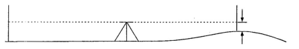
The art of determining relative altitudes of points on the surface of the earth of beneath the surface of the earth is called levelling. This branch of surveying deals with measurement in vertical planes.
LEVEL: The instrument which is used for levelling is known as a level: It consists essentially of the following parts:
- A telescope to provide a line of sight
- A level tube to make the line of sight horizontal
- A levelling head to bring the bubble of the tube level at the centre of its run.
- A tripod to support the instrument
DUMPY LEVEL
It is a simple, compact and stable instrument. The telescope is rigidly fixed to its support and it can neither be rotated about its longitudinal axis and nor it can be removed from its support. Thus it has
- Levelling head
- (ii) Telescope
- (iii) Eye piece
- (iv) Diaphragm screws
- (v) Focussing–screws
- (vi) Ray–shade
- (vii) Longitudinal/Altitude bubble tube
- (viii) Babble tube adjusting screws
- (ix) Cross bubble tube
Advantages and disadvantages of Dumpy Level:
- It is simple in construction with a few movable parts.
- It requires fewer permanent adjustments.
- Adjustment once carried out remains for a longer period.
Levelling Staff
A straight, rectangular wooden rod graduated into meters/feet and further smaller divisions, called a levelling staff. The bottom of the levelling staff represents the zero–reading. In the most common forms, the smallest division is of 5 mm and graduations arc in the form of alternate black and white strips. The purpose of a level (instrument) is to establish a horizontal line of sight. The purpose of the levelling staff is to determine the amount by the which station (i.e. foot of the staff) is above or below the line of sight.
ACE CIVIL ENGINEERING GATE STUDY MATERIALS : CLICK HERE
TECHNICAL TERMS USED IN LEVELLING
Level surface: Level surface is a curved surface which is parallel to the mean spheroidal surface of the earth, such that every point on this level surface is equidistant from the centre of the earth. The surface of still water in a lake represents a level surface. Any line lying on the level surface is known as level line.
Horizontal surface: A surface tangential to the level surface at any point is known as a horizontal surface. It is perpendicular to the plumb line at the tangent point.
Horizontal line: A line lying on the horizontal surface, is known as horizontal line. It is a straight line tangential to the level line.
Vertical line: A line perpendicular to the level line is called a vertical line. The plumb line at any place, is called the vertical line.
Vertical plane: The plane which contains the vertical line at a place is, called a vertical plane.
Vertical angle: The angle between an inclined line and a horizontal line at a place in Vertical plane, is called vertical angle.
Datum Surface: The imaginary level surface with reference to which vertical distance of the points (above or below) are measured, is called Datum Surface. In India the datum adopted for G.T.S. Benchmarks is the mean sea level at Karanchi.
Mean Sea Level datum: The M.S.L. datum adopted by the survey of India for determining the elevation of different points in India is that of Bombay.
Reduced Level (R.L.): The height or depth of a point above or below the assumed datum, is called reduced level (R.L.). It is also known as elevation of the point. Elevations of the points below the datum surface, arc known as negative elevation.
Line of sight: The line passing through the optical centre of the objective, and intersection of cross hairs is known as line of sight.
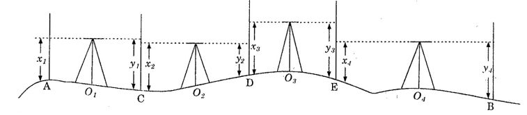
Benchmark (B.M.): A relatively permanent and fixed reference point of known elevation above the assumed datum, is called a bench mark.
Height of the instrument (H.I.): The elevation of the line of sight with respect to assumed datum, is known as height of instrument.
Back Sight (B.S.): The first sight taken on a levelling staff held at point of known elevation, is called back sight. It is also known as +ve sight. Back sight enables the surveyor to obtain the height of the instrument.
Fore sight (F.S.): The sight taken on a levelling staff held at a point of unknown elevation to ascertain the amount by which the point is above or below the line of sight, is called a foresight. Fore sight enables the surveyor to obtain he elevation of the point. It is also generally known as minus sight.
Change point: The point on which both the fore sight and back sight, are taken during the operation of levelling, is called a change point. It is also called a turning point (T.P.)
Intermediate sight: The fore sight taken on a levelling staff held at a point between two turning points, to determine the elevation of that point, is known as intermediate sight.
MADE EASY CIVIL ENGINEERING GATE NOTES : CLICK HERE
Definitions and other technical terms used while making observations with a theodolite.
1. VERTICAL AXIS: The axis about which the theodolite, may be rotated in a horizontal plane, is called vertical axis. Both upper and lower plates may be rotated about vertical axis.
2. HORIZONTAL AXIS ( or Transverse axis): The axis about which the telescope along with the vertical circle of a theodolite, may be rotated in vertical plane is called horizontal axis.
3. LINE OF COLLIMATION: The line which passes through the intersection of the cross hairs of the eye–piece and optical centre of the objective and its continuation, is called line of collimation.
4. AXIS OF THE TELESCOPE: The axis about which the telescope may be rotated is called the axis of telescope.
5. AXIS OF THE LEVEL TUBE: The axis of the level or bubble tube is the straight line tangential to the longitudinal curve of the level tube at the centre of the tube. It is also called the bubble line
6. CENTERING: It means setting up the theodolite exactly over a station mark. It can be done by means of plumb bob.
7. TRANSITING (Plunging or Reversing): The process of turning the telescope in vertical plane through 180 Degrees about its horizontal axis, is known as transiting.
8. SWING: It means turning the telescope in a horizontal plane. If the telescope is rotated in clockwise direction it is known as right swing and if the telescope is rotated in at the anti–clock wise direction, it is known as the left swing.
9. FACE LEFT OBSERVATIONS: When the vertical circle is at the left of the telescope at the time of observations, observations of the angles, are known as face left observation.
10. FACE RIGHT OBSERVATIONS: When the vertical circle on the right of the telescope at the time of observation observations of the angles, are known as face right observation.
11. CHANGING FACE: It is the operation of changing the face of the telescope from left to right and vice–versa.
12. A ‘MEASURE’: It is the determination of the number degrees, minutes and seconds, or grades contained in an angle.
13. A ‘SET’: A ‘set’ of horizontal observation of any angle consists of two horizontal measures, one on the left to and other on the face right.
14. TELESCOPE NORMAL: A telescope is said to be normal when its vertical circle is to its left and the bubble of the telescope is up.
15. TELESCOPE INVERTED: A telescope is said to be inverted or reversed when its vertical circle is to its right and the bubble of the telescope is down.
SURVEYING STUDY MATERIAL FOR SSC JE PDF CIVILENGGFORALL
DOWNLOAD LINK : CLICK HERE
PASSWORD : CivilEnggForAll
OTHER USEFUL BOOKS
- RAJASTHAN STAFF SELECTION BOARD (RSSB) JUNIOR ENGINEER DIPLOMA CIVIL ENGINEERING EXAM 2022 – HINDI & ENGLISH MEDIUM SOLVED PAPER – FREE DOWNLOAD PDF (CivilEnggForAll.com)
- ISRO TECHNICAL ASSISTANT EXAM 2022 – CIVIL ENGINEERING – HINDI & ENGLISH MEDIUM – SOLVED PAPER – FREE DOWNLOAD PDF (CivilEnggForAll.com)
- MADHYA PRADESH PUBLIC SERVICE (MPPSC) COMMISSION – ASSISTANT ENGINEER EXAM – MPPSC AE 2021 CIVIL ENGINEERING – SOLVED PAPER WITH EXPLANATIONS – PDF FREE DOWNLOAD
- BIHAR PUBLIC SERVICE COMMISSION (BPSC) ASSISTANT ENGINEER EXAM – 2022 – CIVIL ENGINEERING – SOLVED PAPER – FREE DOWNLOAD PDF (CivilEnggForAll.com)
- ODISHA PUBLIC SERVICE COMMISSION – OPSC AEE PANCHAYATI RAJ EXAM 2021 – SOLVED PAPER WITH EXPLANATION – FREE DOWNLOAD PDF