
CONTENTS
- HISTORY
- GEOGRAPHY
- POLITY
- GENERAL SCIENCE
- ECONOMY
- MISCELLANEOUS TOPICS
- CURRENT AFFAIRS
HISTORY OF INDIA
The earliest periods of Indian history are known only through reconstructions from archaeological evidence. Since the late 20th century, much new data has emerged. Now we are in a position to divide the ancient Indian history in the following manner: 1. The early prehistoric period (before the 8th millennium BCE) 2. The period of the prehistoric agriculturalists and pastoralists (approximately the 8th to the mid-4th millennium BCE). 3. The Early Indus or Early Harappan period witnessing the emergence of the first cities in the Indus River System (C. 3500–2600 BCE). 4. The Indus or Harappan, civilization (C. 2600–2000 BCE, or perhaps ending as late as 1750 BCE), and 5. The post-urban period, which follows the Indus civilization and precedes the rise of cities in northern India during the second quarter of the 1st millennium BCE (C. 1750–750 BCE)
INDUS VALLEY CIVILISATION (ABOUT 2500 TO 1750 BC)
The Indus valley civilization (IVC) was a unique bronze age civilization and one of the most ancient urban civilizations in the world. The Civilization flourished around the Indus river basin and its tributaries, consist of modern Pakistan and northwestern India. Mohenjodaro is the largest site and Allahdino the smallest site in the civilization.
BASIC FEATURES OF INDUS VALLEY CIVILIZATION
- Town planning: Harappan cities were divided into two parts – a fortified settlement on the high mounds called ‘citadels’ and the main residential areas called ‘lower town’, ‘citadel’ was smaller in area than the ‘lower town’ and located to the west of the cities. The streets ran in straight lines crossing one another at right angles. Houses stood on both sides of the streets. Houses, drains, wells and bathing platforms were made of Klin-burnt bricks. Most of the houses had wells within them and a drainage system carried the waste water to the main underground drain of the street. The main streets ran from north to south varied from 9 feet to 34 ft in width. The Great Bath of Mohenjodaro is the most important public place measuring 39 feet (length) × 23 feet (breadth) × 8 feet (depth) and the great granary found here is largest building measuring 150 feet (length) × 50 feet (breadth). It is located within the citadel and next to the Great Bath.
- Metallurgy: People were familiar with certain new technologies in metallurgy. They used these methods for the production of lead, copper, tin and bronze. Seals were decorated with animal motifs such as elephants, buffaloes, tigers, and most of all unicorns.
- Agriculture: The civilization subsisted primarily by irrigation based agriculture. They used sickles stone blades, which were mounted on wooden sticks for cultivation purposes. Wheat and six-row barley; field peas, mustard, sesame seeds, etc. were grown.
- Political system: It is speculated that the rulers might have been wealthy merchants, or powerful landlords or spiritual leaders.
- Writing system: Their scripts were pictographic and written from right to left like modern Urdu. These scripts are found on various seals, pottery copper tablets, tools etc. It is not deciphered yet.
- Religious life: Harappan people had features of Hinduism, such as worship of the mother Goddess, Pashupati Shiva, Sacred animals, trees etc.
GENERAL ABILITY ACE ACADEMY AE/AEE NOTES: CLICK HERE
Reason for decline of the Indus Valley Civilization
After 700 years, the Harappan cities began to decline. The main reason for decline of the Indus valley civilization was a shift in the course of the river and natural disasters such as drought, floods, etc or long-term climate change. Some scientists also believe that the war with the Aryan civilization can also be a cause of their decline.
THE VEDIC AGE (1500 BC TO 500 BC)
- The Vedic Period or the Vedic Age refers to the period when the Vedic Sanskrit texts were composed in India. During the early part of the Vedic period, the Indo-Aryans settled on the Indo-Gangetic Plains. The Vedic Age was followed by the golden age of Hinduism and classical Sanskrit literature, the Maurya Empire and the Middle Kingdoms of India.
- The Vedas: Aryans developed Vedic culture based on Vedas. The Vedic literature consists of the four Vedas – Rig Veda, Yajur Veda, Sama Veda and Atharva Veda. Besides the Vedas, there are other Holy books like the Brahmanas, the Upanishads, Aranyakas and the epics Ramayana and Mahabharata
- The Rig Veda is the oldest of the four Vedas and it consists of 1028 hymns. Hymns were sung in honour of various gods. It refers to Saptasindhu or the land of seven rivers including the five rivers of the Punjab, namely Jhelum, Chenab, Ravi, Beas and Sutlej along with the Indus and Sarasvati.
- The Yajur Veda consists of various details of the rules which must be adhered at the time of sacrifice.
- The Sama Veda is a set of melody for singing during sacrifices. It is called the book of songs and the origins of Indian music can be traced in it.
- The Atharva Veda contains details of rituals of worship.
Political Organization
The basic unit of political organization was Kula or family. Several families came together to form a village or Grama. The leader of the Grama was known as Gramani. A group of villages constituted a larger unit called visu, headed by vishayapati. The highest political unit was called Jana or tribe. There were two popular bodies called Sabha (Council of Elders), Samiti (General Assembly).
Social Organization
The society was clearly divided into four varnas: bhahmanas, Kshatriyas, vaisyas and sudras in the Vedic period. Each Varna was allowed well-defined jobs, although it was emphasized that Varna was based on birth and two higher varnas were given some privileges.
Religion
The Vedic Aryans worshipped the forces of nature such as Earth, Fire, Wind, Rain and Thunder. There were no temples, and no idol worship in the period. Elaborate rituals were followed during worship.
Economic Condition
The Rig Vedic Aryans were a pastoral people and their main occupation was cattle rearing. When they finally settled in Northern India, they began the practice of agriculture. They were able to clear forests and bring more land under cultivation. Carpentry is another very important profession. Carpenters made chariots and ploughs. Workers of metal made a variety of products with copper and bronze. Spinning was another important profession and cotton and woollen fabrics were made.
GENERAL SCIENCE AE/AEE ACE ACADEMY GATE NOTES: CLICK HERE
GEOGRAPHY
SOLAR SYSTEM
- Our galaxy is milky way Galaxy (or the Akash Ganga). It is spiral in shape.
- The Sun is at the centre of the solar system and one of the stars in the milky way galaxy.
- Hydrogen and helium are the main gases present in the Sun and Weighs 2 × 1027 tons.
- It has a surface temperature of about 6000°C.
- Light (at the speed of 300,000 km per second) takes about 8.5 minutes to reach the Earth from the Sun.
- There are eight planets in the Solar system.
- The sequence of planets according to their distance from the Sun is Mercury, Venus, Earth, Mars, Jupiter, Saturn, Uranus, Neptune. The sequence of planets according to their size (in descending order i.e., from big to small) is Jupiter, Saturn, Uranus, Neptune, Earth, Venus, Mars, Mercury.
THE CONTINENTS
Continents make up the largest landmasses on the planet earth. A continent is larger than an island and is usually made up of multiple countries. There are seven continents in the world although some people do combine Europe and Asia into the single continent Eurasia and others combine North and South America into the American continent.
Africa: It is second as far as population and size among the Earth’s continents. About 1 billion people live in the 54 countries in Africa. This is about 15 percent of the world’s population living on 20 percent of the total land area. The equator passes through the center of the continent with largely tropical climates. The northern and southern portion of Africa has more temperate conditions. Africa is also noted as the birthplace of mankind. The oldest fossil evidence of Homo sapiens was found in the eastern part of the continent.
Antarctica: Antarctica holds a number of firsts among the continents of Earth. The continent is the most southern of the seven continents and includes the South Pole. It is also the least populated with less than 5,000 residents. Antarctica is known as the coldest landmass and has few native plants or animals. Much of the landmass is covered with permanent glaciers.
Asia: Asia covers nearly 9 percent of the earth’s surface making it the largest of the continents. It is also the home to the most people with an estimated population of 4.3 billion. Asia is defined as the eastern portion of the Eurasia continent with the Ural river and mountains serving as the dividing line with Europe. Asia contains some of the oldest civilizations in the world including the Chinese and Japanese nations. The continents large population makes it an important part of the world economy. Asia includes the Saudi Arabia peninsula with the oil rich countries including the United Arab Emirates and Kuwait.
Australia: The continent of Australia includes the mainland of the country Australia and the island nations of New Guinea, Tasmania and Seram. During ice ages, when much of the world’s water was frozen in glaciers, the Australian mainland was connected by land bridges to these islands. Australia has a wide variety of animals and plants many of which are unique in the world. The continent first was inhabited by man nearly 45,000 years ago. European inhabitants came onto the Australian landmass in the 1700s. Australia is the most isolated and remote of the continents and has been least influenced by migrations of people, plants and animals.
Europe: The western portion of the Eurasian continent is known as Europe. It is noted as one of the smallest of the continents, with 7 percent of the world’s landmass. However, Europe is home to about 11% of Earth’s population, and is the second most densely populated continent, with 134 people per square mile, behind Asia’s 203 people per square mile. Europe, by definition, includes the continental mainland ending in the east at the Ural Mountains in Russia. Europe also includes islands such as Iceland and Sicily, and the islands of the British Isles. The British Isles consist of the large island that is home to England, Scotland, and Wales, and is called Great Britain; the British Isles also include the small island that contains Northern Ireland and the Republic of Ireland, and several much smaller surrounding islands
North America: The North American continent includes the Latin American regions that serve as a connection between North and South America. North America makes up about 17 percent of the world’s landmass and is home to about 8 percent of the people. This population of about 529 million people live in about 23 independent countries. The earliest human inhabitants in North America were from Asia and crossed into Alaska over the Bering land bridge during an ice age. The arrival of Europeans occurred in the mid 1600s. This population is now dominant in North America.
South America: South American continent is the southern portion of the larger American continent. The equator passes through the continent yielding a tropical climate to much of the landmass with temperate conditions possible in the south. The indigenous people of South America may have migrated south from North America although the majority of its current 371 million residents are of European descent. The population bases are largely along the Pacific and Atlantic coasts with large portions of the inland regions hosting small and widely spread populations. South America includes the Andes Mountains which comprise the longest range of peaks in the world.
GENERAL AWARENESS RRB JE EXAM STUDY MATERIAL: CLICK HERE
THE OCEANS
There are five oceans which cover the surface of our globe. They cover more than 71% of the Earth’s surface.
- Pacific Ocean: The largest coral reef in the world is located off the Australian coast and is called the Great Barrier Reef. The ring of fire is also located in the Pacific Ocean.
- Atlantic Ocean: The Atlantic is the second biggest ocean in the world and is between the continents of America and Europe and Africa. The Atlantic Ocean is about half the size of the Pacific Ocean and covers roughly 20% of the Earth’s surface. However it is growing in size as it is spreading along the Mid-Atlantic Coasts. Sharks, such as this Thresher Shark swimming in the gulf stream, are found in the waters of the Atlantic. The Mid-Atlantic Ridge is the longest mountain range on Earth. It spreads from Iceland to Antarctica beneath the Atlantic.
- Indian Ocean: The Indian Ocean is located between Africa and Austral-Asia. The waters of the Indian Ocean provide the largest breeding grounds of the world for humpback whales. Also found in the Indian Ocean, a fish which was thought to be extinct was discovered there: the Coelacanth is found in the warm waters off the Comoro islands between Mozambique and Madagascar. The Northern Indian Ocean also is the most important transport route for oil as it connects the oil-rich countries of the Middle East Each with Asia. Every day tankers are carrying a cargo of 17 million barrels of crude oil from the Persian Gulf on its waters.
- Arctic Ocean: The Arctic Ocean is located around the North Pole across the Arctic circle. There are many polar bears living on the Arctic ice. A jellyfish with the funny name ‘Lion’s mane jellyfish’ can also be found in the Arctic Ocean’s waters. It grows up to 2.4m or 8 feet across and lives on plankton and fishes. The Arctic Ocean’s ice covers are shrinking by 8% every ten years. Many Arctic ground features are named after early Arctic explorers, like Nansen Basin or Mendeleyev Ridge.
- Southern Ocean: The Southern Ocean is located around the South Pole across the Antarctic circle in the Southern Hemisphere off Antarctica. The Southern Ocean is the home of Emperor Penguins and Wandering Albatrosses.
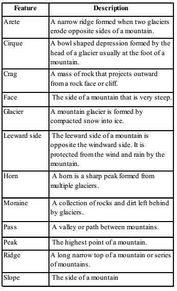
MOUNTAINS
A mountain is a geological landform that rises above the surrounding land. Typically a mountain will rise at least 1,000 feet above sea level. Some mountains exceed 10,000 feet above sea level with the highest mountain in the world, Mount Everest, rising 29,036 feet. Small mountains (below 1,000 feet) are usually called hills. They are most often formed by movement of the tectonic plates in the Earth’s crust. Great mountain ranges like the Himalayas often form along the boundaries of these plates. Tectonic plates move very slowly. It can take millions and millions of years for mountains to form.
Types of Mountains
There are three main types of mountains: fold mountains, faultblock mountains, and volcanic mountains. They get their names from how they were formed.
- Fold mountains: Fold mountains are formed when two plates run into each other or collide. The force of the two plates running into each other causes the Earth’s crust to crumple and fold. Many of the world’s great mountain ranges are fold mountains including the Andes, Himalayas, and the Rockies.
- Fault-block mountains: Fault-block mountains are formed along faults where some large blocks of rock are forced upwards while others are forced down. The higher area is sometimes called a “horst” and the lower a “graben” (see the picture below). The Sierra Nevada Mountains in the western United States are faultblock mountains.
- Volcanic mountains: Mountains that are caused by volcanic activity are called volcanic mountains. There are two main types of volcanic mountains: volcanoes and dome mountains. Volcanoes are formed when magma erupts all the way to the surface of the Earth. The magma will harden on the Earth’s surface, forming a mountain. Dome mountains are formed when a large amount of magma builds up below the Earth’s surface. This forces the rock above the magma to bulge out, forming a mountain. Examples of volcanic mountains include Mount Fuji in Japan and Mount Mauna Loa in Hawaii.
GENERAL AWARENESS STUDY MATERIAL FOR SSC JE PDF CIVILENGGFORALL
DOWNLOAD LINK : CLICK HERE
PASSWORD : CivilEnggForAll
OTHER USEFUL BOOKS
- RAJASTHAN STAFF SELECTION BOARD (RSSB) JUNIOR ENGINEER DIPLOMA CIVIL ENGINEERING EXAM 2022 – HINDI & ENGLISH MEDIUM SOLVED PAPER – FREE DOWNLOAD PDF (CivilEnggForAll.com)
- ISRO TECHNICAL ASSISTANT EXAM 2022 – CIVIL ENGINEERING – HINDI & ENGLISH MEDIUM – SOLVED PAPER – FREE DOWNLOAD PDF (CivilEnggForAll.com)
- MADHYA PRADESH PUBLIC SERVICE (MPPSC) COMMISSION – ASSISTANT ENGINEER EXAM – MPPSC AE 2021 CIVIL ENGINEERING – SOLVED PAPER WITH EXPLANATIONS – PDF FREE DOWNLOAD
- BIHAR PUBLIC SERVICE COMMISSION (BPSC) ASSISTANT ENGINEER EXAM – 2022 – CIVIL ENGINEERING – SOLVED PAPER – FREE DOWNLOAD PDF (CivilEnggForAll.com)
- ODISHA PUBLIC SERVICE COMMISSION – OPSC AEE PANCHAYATI RAJ EXAM 2021 – SOLVED PAPER WITH EXPLANATION – FREE DOWNLOAD PDF