

TOPICS COVERED
- Transportation planning and process
- Forecasting future traffic flows
- Scheme appraisal for highway projects
- Basic elements of highway traffic analysis
- Design of Highway intersections
- Geometric alignments and design
- Highway pavement materials and design
- Structural design of pavement thickness
- Pavement maintenance
IMPORTANCE OF HIGHWAYS
Highways are vitally important to a country’s economic development. The construction of a high quality road network directly increases a nation’s economic output by reducing journey times and costs, making a region more attractive economically. The actual construction process will have the added effect of stimulating the construction market.
Highway planning strategies
When the highway planning process takes place within a large urban area and other transport options such as rail and cycling may be under consideration alongside car-based ones, the procedure can become quite complex and the workload involved in data collection can become immense. In such circumstances, before a comprehensive study can be undertaken, one of a number of broad strategy options must be chosen
– The land use transportation approach
– The demand management approach
– The car-centred approach
– The public transport-centred approach.
HIGHWAY ENGINEERING IES MASTER GATE MATERIAL : CLICK HERE
Land use transportation approach
Within this method, the management of land use planning is seen as the solution to controlling the demand for transport. The growing trend where many commuters live in suburbs of a major conurbation or in small satellite towns while working within or near the city centre has resulted in many using their private car for their journey to work. This has led to congestion on the roads and the need for both increased road space and the introduction of major public transport improvements. Land use strategies such as the location of employment opportunities close to large residential areas and actively limiting urban sprawl which tends to increase the dependency of commuters on the private car, are all viable land use control mechanisms.
The demand management approach
The demand management approach entails planning for the future by managing demand more effectively on the existing road network rather than constructing new road links. Demand management measures include the tolling of heavily trafficked sections of highway, possibly at peak times only, and car pooling, where high occupancy rates within the cars of commuters is achieved voluntarily either by the commuters themselves, in order to save money, or by employers in order to meet some target stipulated by the planning authority. Use of car pooling can be promoted by allowing private cars with multiple occupants to use bus-lanes during peak hour travel or by allowing them reduced parking charges at their destination.
The car-centred approach
The car-centred approach has been favoured by a number of large cities within the US, most notably Los Angeles. It seeks to cater for future increases in traffic demand through the construction of bigger and better roads, be they inter-urban or intra-urban links. Such an approach usually involves prioritising the development of road linkages both within and between the major urban centres. Measures such as in-car information for drivers regarding points of congestion along their intended route and the installation of state-of-the-art traffic control technology at all junctions, help maximise usage along the available road space.
TRANSPORTATION ENGINEERING ACE GATE STUDY MATERIAL : CLICK HERE
The public transport-centred approach
In the public transport-centred approach the strategy will emphasise the importance of bus and rail-based improvements as the preferred way of coping with increased transport demand. Supporters of this approach point to the environmental and social advantages of such a strategy, reducing noise and air pollution and increasing efficiency in the use of fossil fuels while also making transport available to those who cannot afford to run a car. However, the success of such a strategy depends on the ability of transport planners to induce increasing numbers of private car users to change their mode of travel during peak hours to public transport. This will minimise highway congestion as the number of peak hour journeys increase over the years. Such a result will only be achieved if the public transport service provided is clean, comfortable, regular and affordable.
Basic physical elements of a highway
The basic features of a highway are the carriageway itself, expressed in terms of the number of lanes used, the central reservation or median strip and the shoulders (including verges). Depending on the level of the highway relative to the surrounding terrain, side-slopes may also be a design issue.
Main carriageway
The chosen carriageway depends on a number of factors, most notably the volume of traffic using the highway, the quality of service expected from the installation and the selected design speed. In most situations a lane width of 3.65m is used, making a standard divided or undivided 2-lane carriageway 7.3 m wide in total.These widths are as stated in TD 27/96 (DoT, 1996). Any reduction or increase in these widths is considered a departure from standard. The stated lane widths should only be departed from in exceptional circumstances such as where cyclists need to be accommodated or where the number of lanes needs to be maximised for the amount of land available. In Scotland and Northern Ireland, a total carriageway width of 6.0m may be used on single carriageway all-purpose roads where daily flow in the design year is estimated not to exceed 5000 vehicles.
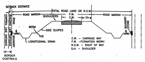
Central reservation
A median strip or central reservation divides all motorways/dual carriageways. Its main function is to make driving safer for the motorist by limiting locations where vehicles can turn right (on dual carriageways), completely separating the traffic travelling in opposing directions and providing a space where vehicles can recover their position if for some reason they have unintentionally left the carriageway. In urban settings, a width of 4.5m is recommended for 2/3-lane dual carriageways, with 4.0m recommended for rural highways of this type. While these values should be the first option, a need to minimise land take might lead to reductions in their value. Use of dimensions less than those recommended is taken as a relaxation rather than a departure from the standard (TD 27/96). (The term ‘relaxation’ refers to a relaxing of the design standard to a lower level design step, while a ‘departure’ constitutes non-adherence to a design standard where it is not realistically achievable.Use of central reservation widths greater than the values stated is permitted. Its surfacing material should be different to that on the carriageway itself. Grass, concrete or bituminous material can be used.
Hard strips/verges
On single carriageway roads (normal and wide), a 1m wide hardstrip and a 2.5m wide grassed verge is employed on the section of roadway immediately adjacent to the main carriageway on each side. On rural 2 and 3-lane motorways, a hard shoulder of 3.3m and a verge of 1.5m are the recommended standard. On rural 2/3-lane dual carriageways, the 1m wide hardstrip and 2.5m wide verge is detailed on the nearside with a 1m hardstrip on the offside. For urban motorways the verge dimension varies while the hard shoulder is set at 2.75m wide. The proper geometric design of a highway ensures that drivers use the facility with safety and comfort. The process achieves this by selecting appropriate vertical and horizontal curvature along with physical features of the road such as sight distances and superelevation. The ultimate aim of the procedure is a highway that is both justifiable in economic terms and appropriate to the local environment.
TRANSPORTATION ENGINEERING MADE EASY GATE NOTES : CLICK HERE
Design speed, stopping and overtaking sight distances
The concept of ‘design speed’ lies at the centre of this process. The design speed of a highway serves as a guide in the selection of the physical features referred to above. Selection of the correct design speed ensures that issues of both safety and economy in the design process are addressed. The chosen design speed must be consistent with the anticipated vehicle speeds on the highway under consideration. The standard design speeds are 50km/hr, 60km/hr, 70km/hr, 85km/hr, 100 km/hr and 120km/hr. These bands are based on the premise that it is considered acceptable if 85% of drivers travel at or below the designated design speed for a given highway, generally inducing a situation where approximately 99% of the drivers travel at or below one speed category above the design speed (i.e. if the speed limit is set at 85km/hr, it can be assumed that 85% of the drivers will travel at or below this value while 99% will travel at or below 120km/hr). The speed bands are thus related to each other by a factor equal to the fourth root of 2, taken as being approximately 1.19. Thus, if the chosen design speed is by definition the 85th percentile speed for that highway, then the next speed band up will constitute its 99th percentile speed.
The geometric properties associated with the design speed of a highway constitute ‘desirable values’ at which 85% of the drivers are travelling with complete safety. The geometric values of the next design speed up constitute a standard at which 99% of the drivers can travel safely at the original design speed. Conversely, the geometric values of the next design speed down will constitute a relaxation at which only 50% of the drivers will be in a position to travel with complete safety at the original design speed. Such values constitute absolute minimum values. However, these may have to be adopted in difficult design conditions where many constraints both physical and otherwise exist. Thus, in conclusion, the 85th percentile speed is selected as the design speed on the basis that it constitutes the most appropriate and judicious choice, as use of the 99th percentile would prove extremely expensive while extensive use of the 50th percentile may prove unduly unsafe for the faster travelling vehicles.
HIGHWAY ENGINEERING TEXTBOOK BY CIVILENGGFORALL
DOWNLOAD LICK : CLICK HERE
PASSWORD : CivilEnggForAll
OTHER USEFUL BOOKS
- RAJASTHAN STAFF SELECTION BOARD (RSSB) JUNIOR ENGINEER DIPLOMA CIVIL ENGINEERING EXAM 2022 – HINDI & ENGLISH MEDIUM SOLVED PAPER – FREE DOWNLOAD PDF (CivilEnggForAll.com)
- ISRO TECHNICAL ASSISTANT EXAM 2022 – CIVIL ENGINEERING – HINDI & ENGLISH MEDIUM – SOLVED PAPER – FREE DOWNLOAD PDF (CivilEnggForAll.com)
- MADHYA PRADESH PUBLIC SERVICE (MPPSC) COMMISSION – ASSISTANT ENGINEER EXAM – MPPSC AE 2021 CIVIL ENGINEERING – SOLVED PAPER WITH EXPLANATIONS – PDF FREE DOWNLOAD
- BIHAR PUBLIC SERVICE COMMISSION (BPSC) ASSISTANT ENGINEER EXAM – 2022 – CIVIL ENGINEERING – SOLVED PAPER – FREE DOWNLOAD PDF (CivilEnggForAll.com)
- ODISHA PUBLIC SERVICE COMMISSION – OPSC AEE PANCHAYATI RAJ EXAM 2021 – SOLVED PAPER WITH EXPLANATION – FREE DOWNLOAD PDF